|
|
 |

|
|
>North
About 12.2km, About 4hrs. : From Kumano-shi Station to Michi-no-eki Park
Shichiri-mihama --- a little hard walk
>South
About 14.4km, About 5hrs. : From Michi-no-eki Park Shichiri-mihama to Shingu
Station --- a little hard walk |

|
|
Hama-kaido Road leads to "Kumano Hayatama-taisha Shrine," one of "Kumano Sanzan (three big shrine in)."
From Kumano city trail is along Shichiri-mihama Beach and Route 42. It
is so hard to walk on beach that you can walk on bank or Route 42 if you
don't have much physical strength.
There isn't no pass on this trail, but many pilgrims died when they cross
rivers. There are some tombstones of them.
Let's try to get to Hayatama-taisha Shrine ! |

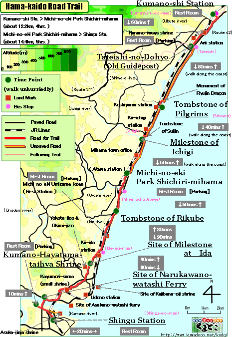
| "Hama-kaido Road trail" brief Map |
|
  click a map and you can see a big PDF map for printing click a map and you can see a big PDF map for printing |
 |
( North )
Kumano-shi Station ->(even, paved road and beach, 60mins.)-> Tateishi-no-Dohyo ->(even, paved road and beach, 80mins.)-> Tombstone of Pilgrims ->(even, paved road and beach, 40mins.)-> Milestone of Ichigi ->(even, paved road and beach, 60mins.)-> Michi-no-eki Park Shichiri-mihama
( South )
Michi-no-eki Park Shichiri-mihama ->(even, paved road, 60mins.)-> Tombstone of Rikube ->(even and slight uphill, paved road, 90mins.)-> Site of Milestone at Ida ->(slight downhill and even, paved road, 80mins.)-> Site of Narukawano-watashi Ferry ->(even, paved road, 20mins.)-> Hayatama-taisha Shrine ->(even, paved road, 30mins.)-> Shingu Station |

|
|
| by car |
Nagoya ==(Highway & Route 42 / 4hrs.)== Odomari Station ==(Route42/5mins.)==
Kumano-shi Station ==(Route42/20mins.)== Michi-no-eki Park Shichiri-ihama
==(Route42/20mins.)== Hayatama-taisha Shrine ==(Route42/5mins.)== Shingu
Station |
| by train and bus |
Nagoya Station ==(Nanki Express / 2hrs. and 50mins.)== Kumano-shi Station
==(Local / 15mins.)== Atawa Station ==(Route42/15mins.)== Shingu Station |
|
|
|
 |


