|
|
 |

|
|
About 14km, About 5hrs.: From Shiko Bus Stop to Hongu-taisha Shrine
--- a little hard walk |
|
|
This is the final trial on "Ise-ji Route," which is from Tamaru
to Hongu-taisha Shrine.
From Shiko on the Kumano-gawa River, you have to walk over Banze-toge Pass
with continuous uphill on paved road. After Banze-toge Pass, the trail
joins "Kokumotorikoe trail," a part of "Nakahechi Route,"
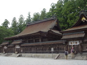
and leads to Hongu-taisha Shrine, which is one of the "Kumano-sanzan
(three sacred sites)." |
| "From Shiko to Hongu-taisha Shrine trail" brief Map |
|
 click a map and you can see a big PDF map for printing click a map and you can see a big PDF map for printing |
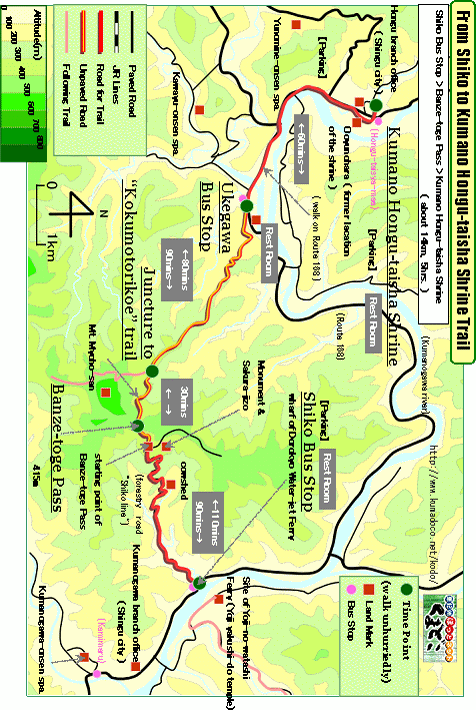 |
| Shiko Bus Stop ->(uphill, paved road and unpaved road, 120mins.)-> Banze-toge Pass ->(downhill and slight uphill, unpaved road, 30mins.)-> Juncture to "Kokumotorikoe" trail ->(downhill, unpaved road, 80mins.)-> Ukegawa Bus Stop ->(even, paved road, 60mins.)-> Hongu-taisha Shrine |
|
|
| by car |
>Nagoya ==(Highway & Route 42 / 4hrs.)== Kumano-shi Station ==(Route42
& 311/40mins.)== Senmaida-Toritoge-Iriguchi Bus Stop ==(Route 311 &
169 & 168/1hr.)== Hongu-taisha Shrine
>Nagoya ==(Highway & Route 42 / 4hrs. and 50mins.)== Hayatama-taisha
Shrine ==(Route 168 / 50mins.)== Shiko Bus Stop ==(Route 168 / 15mins.)==
Hongu-taisha Shrine |
| by train and bus |
Nagoya Station ==(Nanki Express / 3hrs.)== Shingu Station ==(Local Bus
/ 1hrs.)== Shiko Bus Stop ==(Local Bus / 15mins.)== Hongu-taisha Shrine |
|
|
|
 |