|
|
 |

|
|
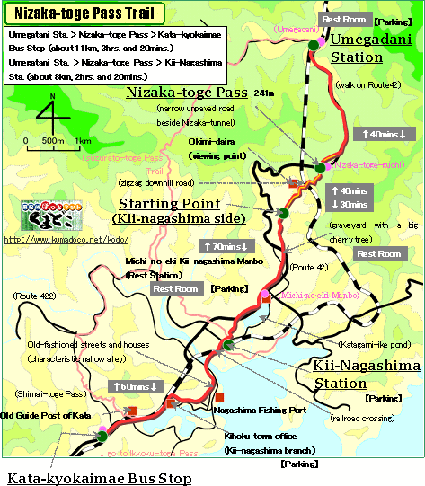
About 11km, About 3hrs. and 20mins.:From Umegadani Station to Kata-kyokai-mae
Bus Stop
(About 8km, About 2hrs. and 20mins.:From Umegadani Station to Kii-Nagashima
Station)
--- Very Easy walk (from Kii-Nagashima Station to Umegadani Station, a
little harder) |
|
|
Nizaka-toge Pass became the main route between Ise and Kii on behalf of "Tsuzurato-toge Pass", in an early stage of Edo Period(1603-1868).
At "Okimi-daira", a viewing point of this trail, a famous travel
writer Suzuki Bokushi made the Haiku to see a good view of Kumano-nada
sea.
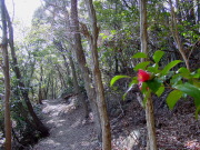
Through this trail, there is many natural forest, which teaches us the
usual vegitation of this region. You can enjoy a comfortable walk. |
| "Nisaka-toge Pass Trail" brief Map |
|
 click a map and you can see a big PDF map for printing click a map and you can see a big PDF map for printing |
|
| Umegadani Station ->(slight uphill, paved road, 40mins.)-> Nizaka-toge Pass ->(gentle and sharp downhill, unpaved road, 30mins.)-> Starting Point ->(even, paved road, 70mins.)-> Kii-Nagashima Station ->(even, paved road, 60mins)-> Kata-kyokaimae Bus Stop |
|
|
| by car |
Nagoya ==(Highway & Route 42 / 2hrs. and 20mins.)== Umegadani Station
==(Route 42 / 10mins.)== Michi-no-eki Kii-Nagashima Manbo ==(Route 42
/ 5mins.)== Kii-Nagashima Station |
| by train |
Nagoya Station ==(Nanki Express / 2hrs.)== Kii-Nagashima Station ==(Local
/ 10mins.)== Umegadani Station |
|
|
|
 |